Polar vortex to bring brutal cold and snow this weekend
The coldest air yet of the winter season — by far — is on its way south from Canada, as the Polar Vortex vacates its home in the Arctic to pay the U.S. a visit. Ahead of that Arctic air will be another major snowstorm for the Northeast, less than a week after the region saw its biggest snowfall in years.
Both of these weather systems will mark the beginning of the coldest week of the winter in the eastern half of the nation, and the cold may stick around at least through the middle of the month. This is all due to very slow moving and blocky steering winds pushing weather systems out of their normal locations and locking the pattern in place for long stretches of time.
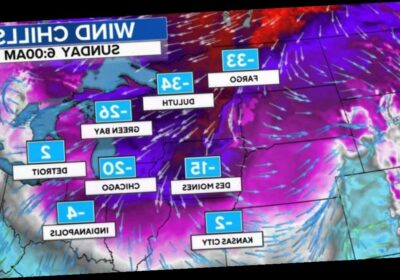
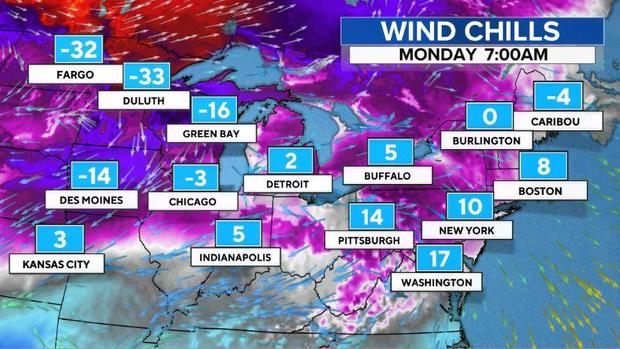
The Arctic air is already invading the Upper Midwest, with temperatures expected to be below zero by Saturday morning from Montana to Wisconsin. On Sunday, the cold air will penetrate further south and east into the Great Lakes and mid-Mississippi Valley. Wind chills will range from a mind-numbing -30 to -40 degrees Fahrenheit in the Upper Midwest in places like Fargo and Minneapolis, to a bitterly cold -20 in Chicago.
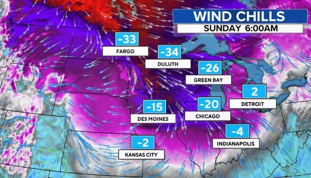
This push of Arctic air is due to a rather convoluted pattern across the Arctic and Polar regions, which started to evolve in early January. At that time, a phenomenon known as a Sudden Stratospheric Warming took place high above the North Pole in which the temperatures 50,000 to 100,000 feet above the ground spiked 100 degrees Fahrenheit in a few days. This is a natural occurrence which happens, on average, every couple of years.
CBS News wrote about the phenomenon at around that time, and projected winter’s wrath would arrive later in January. That’s because about two weeks after the stratosphere rapidly warms, the event typically reaches the surface and throws weather patterns off-kilter in the Arctic.
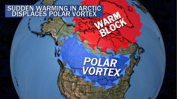
In this case, the event helped bolster a mountain of unusually warm air near Greenland, known as an atmospheric block. That block forces the jet stream to steer around it and the cold air is displaced south from the Arctic to the mid-latitudes.
The cold air doesn’t always land in the same locations. Last month, the first batch of Arctic air settled into Siberia where temperatures dropped to -73 degrees Fahrenheit. A modified version of that airmass is now moving to the other side of the globe into Southern Canada and the northern tier of the U.S..
The gigantic arctic air mass that’ll be lurking on the CONUS’s doorstep next week originated over Siberia in late January.
Siberian express 🚂🚂🚂 pic.twitter.com/Ef0SewQF4C
On Monday, a small portion of the cold air mass will slip eastward, bringing colder air to the Northeast with wind chills in the single digits. But the bulk of the Arctic air will remain in the Midwest.
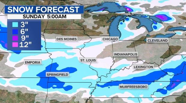
Ahead of the Arctic cold front, later Saturday and into Sunday, an area of low pressure will develop in the Tennessee Valley and slide into the Mid-Atlantic. Initially the snow is expected to be fairly light, but once the storm reaches the East Coast it will get much heavier.
Snow will develop from the Plains to the Ohio Valley Saturday and Saturday night. A general accumulation of a couple to a few inches will fall from Missouri to Kentucky and Tennessee.
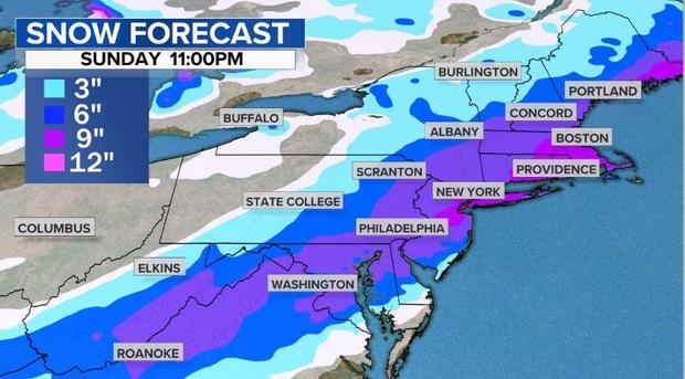
The main event will take place on Sunday as the storm intensifies along the Eastern Seaboard. Heavy snow is expected from Washington, D.C., to Philadelphia and New York City to Boston. Just like last weekend, snowfall rates will once again accumulate at 1-2 inches per hour. But this time, the storm will move much faster, so the event will only last about eight hours.
However, even with its rapid movement, the intensity of the snow combined with a very cold atmosphere should allow 5 to 10 inches of snow to fall, with some isolated amounts up to a foot. The heaviest band should set up over the I-95 corridor from D.C to Boston.
The snow will move out on Sunday night, but the cold air will linger for most of the upcoming week — meaning the snow on the ground will likely remain for quite some time.
Source: Read Full Article